The lack of accurate rainfall measurements in developing countries poses problems in monitoring crop yields, which in turn can make it difficult for the providers of rainfall-based index insurance to gauge risks and set rates accurately.
Existing instruments available for monitoring rainfall—including rain gauges, radar, and satellites—all have limitations. For example, rain gauges provide a local observation that does not faithfully represent the measured region in its entirety. Satellite rainfall retrievals made from space may be inaccurate near ground level. Due to budgetary constraints, rain gauges and radar equipment are often sparingly deployed in developing countries.
A new initiative led by researchers from IFPRI, Cornell University, and the Israeli startup AtmosCell Labs will use commercial microwave links (CMLs) to estimate rainfall in crop production monitoring and help design better rainfall-based index insurance in developing countries. The proposed approach has huge potential to provide extensive rainfall measurements from low-income countries where weather-monitoring capabilities are often quite limited.
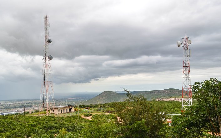
CMLs form the infrastructure for data transmission between cellular communication base stations. These wireless microwave links are widely deployed by cellular providers and typically situated just a few tens of meters above ground level. Rainfall causes attenuation to the radio beams between transmitter and receiver in the network. As a result, quantitative precipitation estimates can be made based on changes observed in the quality of the electromagnetic signals.
This is a sustainable long-term solution, as it relies on existing infrastructure and data collection by telecommunication companies. The implementation cost is minimal because the data is already collected and logged by many cellular operators in the course of monitoring quality of service anyway.
Since wireless communication systems are widely installed in the field, they can be used as a complementary tool and as a replacement for conventional instruments where those aren’t available. Many CMLs are installed in mountainous regions and other hard-to-reach areas, enabling observations in places that have been hard to access in the past or where rainfall has never been measured before.
The multidisciplinary team is working with data from a number of cellular network operators, and carrying out research on the topic in several directions. The team recently published a paper with a group from the Faculty of Geo-Information Science and Earth Observation (ITC) at the University of Twente in the Netherlands, presented at the 16th International Conference on Environmental Science and Technology conference in Rhodes, Greece, in September. The paper demonstrated the potential spatial advantage that it is sometimes possible to achieve using CMLs for monitoring rainfall, based on measurements in an agricultural area near Kericho, Kenya.
By combining data from the household survey, rain gauges, CMLs, weather stations, and satellite, the team aims to explore the value-added potential of high-resolution rainfall measurements in crop production monitoring and to quantify the reduction of basis risk in real-world index insurance, when compared to the standard methods of weather stations, radar, and satellites.
This technology-driven, data-based systems approach to address key societal challenges lying at the core of food systems and sustainable development in developing countries aligns squarely with the missions of IFPRI, Cornell University, and AtmosCell Labs, as well as the UN Sustainable Development Goals. Ultimately, we hope, farmers will benefit from better designed rainfall-based index insurance and poor households will benefit from more accurate crop yield monitoring.
Noam David is the founder of AtmosCell Labs; Oliver Gao is a Professor of Civil and Environmental Engineering at Cornell University; Yanyan Liu is a Senior Research Fellow with IFPRI’s Markets, Trade, and Institutions Division.
This research was funded by 2018 and 2019 Inspire Challenge grants from the CGIAR Platform for Big Data in Agriculture.
