


With climate change impacts, deforestation, and land use changes accelerating around the world, the need for mapping croplands—which cover 1.2 billion hectares, approximately 12% of Earth’s surface—is growing more urgent. Sustaining a growing global population, while protecting vital natural ecosystems, requires more efficient crop systems that sustainably produce more on less land and less water. Understanding the precise cultivation methods and geographical distribution of specific crops is crucial for framing research initiatives, establishing benchmarks, and guiding investment choices to move toward those goals.
IFPRI’s Spatial Allocation Model (SPAM) has provided a key tool for assessing croplands since its introduction in 2000. SPAM is a global model that shows those patterns of crop areas and yields by management systems—providing critical information for sustainable supply chains, water stress models, and an understanding of agricultural production worldwide. A new version of the model—SPAM2020—was launched at an April 29 webinar.
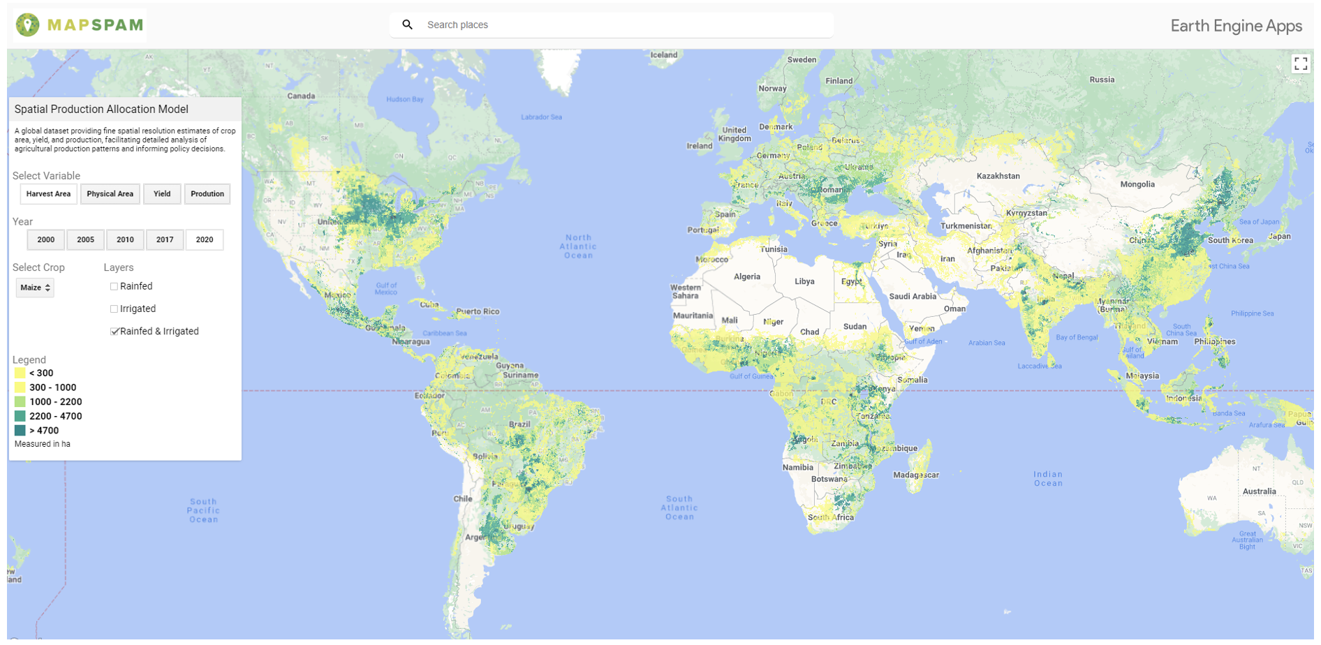
Figure 1: SPAM2020 user interface
IFPRI
IFPRI Senior GIS Coordinator Zhe Guo outlined improvements in the revised model and provided a short overview of how SPAM has and can be used. To develop SPAM2020, IFPRI partnered with the Land & Carbon Lab at the World Resources Institute to update the model and global map to include data and inputs from 2020 and encompasses 46 crops and crop groups, covering over 90% of global crop area. This is the latest in a series of revisions to the model and accompanying maps—earlier updates were done in 2005 and 2010, and in 2017 for sub-Saharan Africa.
Speakers touched on the practical uses of SPAM. Andy Jarvis, Director of Future of Food at the Bezos Earth Fund called SPAM an “alpha dataset” in helping transform the global food system. Other speakers included Michiel van Dijk, a Senior Researcher at Wageningen University and Research (WUR) and the International Institute for Applied Systems Analysis (IIASA), along with Deepak Ray, Senior Scientist in Global Landscapes, University of Minnesota, and Elise Mazur, GIS Research Associate, Land & Carbon Lab.
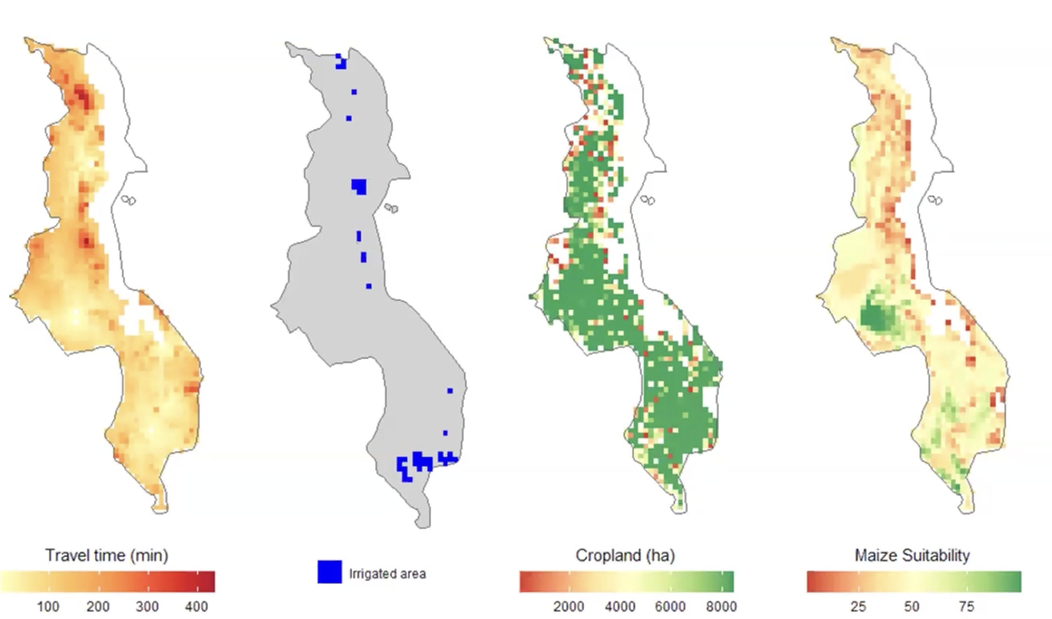
To develop SPAM2020, the IFPRI team collected statistical data on field and tree crops from census and survey sources such as FAOSTAT, national statistics offices, ministries of agriculture, and household surveys. This data included harvested area, yield, and production for 46 crops or crop groups (e.g. vegetables) circa 2020, using 2019-2021 averages.
The team used this information to run SPAM, breaking the data down into 10×10 km pixels for a number of variables including: Crop management system (rainfed or irrigated); administrative level (county or subnational); spatial distribution of cropland area over grid cells based on satellite; biophysical suitability of crops by Global Agro-Ecological Zone (GAEZ); and crop areas, yields, and production. These data were used to create global maps for the physical area, harvested area, yield and production for each crop or crop group.
SPAM2020 includes many updates and improvements that allow users to gain a better understanding of the input data and modeling process. The revised model does more than just update the baseline to 2020; it includes information on several crops not in previous versions, such as rubber. A newly developed SPAM data viewer tool allows users and researchers to delve into SPAM time series data via the Google Earth Engine App.
In addition, all SPAM source code and most input data are openly accessible for the first time. To further enhance accessibility, SPAM2020 was redeveloped in R language and published on GitHub. The new SPAM model has also made the selection and number of crops more flexible, and the scale and resolution adjustable. Enhancing SPAM’s accessibility and usability by sharing the data, code, and methodology allows users to take the statistical data and run their own spatial allocation, customizing the data to their needs and spatial resolution. This open access approach is key to driving innovation and collaboration. This spatial distribution of crop types including area, yield, and production is valuable for activities such as monitoring shifts in land use and productivity trends, strategizing resource allocation, and evaluating food security measures.
Zhe Guo is Senior GIS Coordinator with IFPRI’s Foresight and Policy Modeling (FPM) Unit; Eleanor Jones is an FPM Program Coordinator; Liangzhi You is an FPM Senior Research Fellow.
You can contact the SPAM2020 team using this link and join the SPAM community here.